Why Defense CV Teams Can Never Collect Enough Training Data
Defense and drone CV engineers face a persistent issue: field-collected data falls short for robust models, leaving gaps in edge cases like rare weather or occluded targets. No amount of flights or ground tests delivers the volume, diversity, or labels needed for mission-ready detection. Synthetic data addresses this directly by generating precise, scalable datasets that cut real-world collection needs by 50-90%.
Limits of Field Data Collection
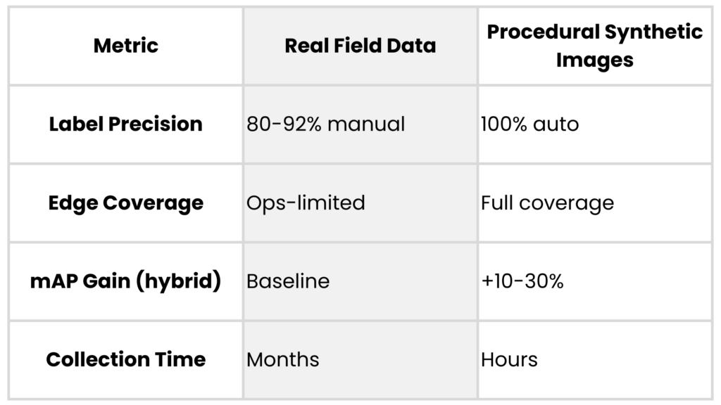
Field campaigns for drone payloads or ISR systems demand images across altitudes from 50m to 5km, lighting from dawn haze to IR night glow, and sensors like electro-optical (EO) vs. multispectral. Each sortie costs $200k+, yields only thousands of frames, and misses 80% of operational variations due to weather, regs, or classification locks.
Real data label accuracy hovers at 85-95% even with experts, prone to human error on small/distant objects. Teams burn months on campaigns that still leave models undertrained for novel scenes.
Security Constraints on Data Sharing
Classified data can’t tap open sources like COCO or crowdsource platforms. Export controls block partner exchanges; even internal siloed teams wait weeks for approvals. This fragments datasets, forcing siloed training on narrow domains and inflating domain gaps when deployed.
Adversarial risks compound it: leaked real imagery aids enemies, while synthetics stay clean and iterative without audits.
Synthetic Data: An Advantage for CV Teams
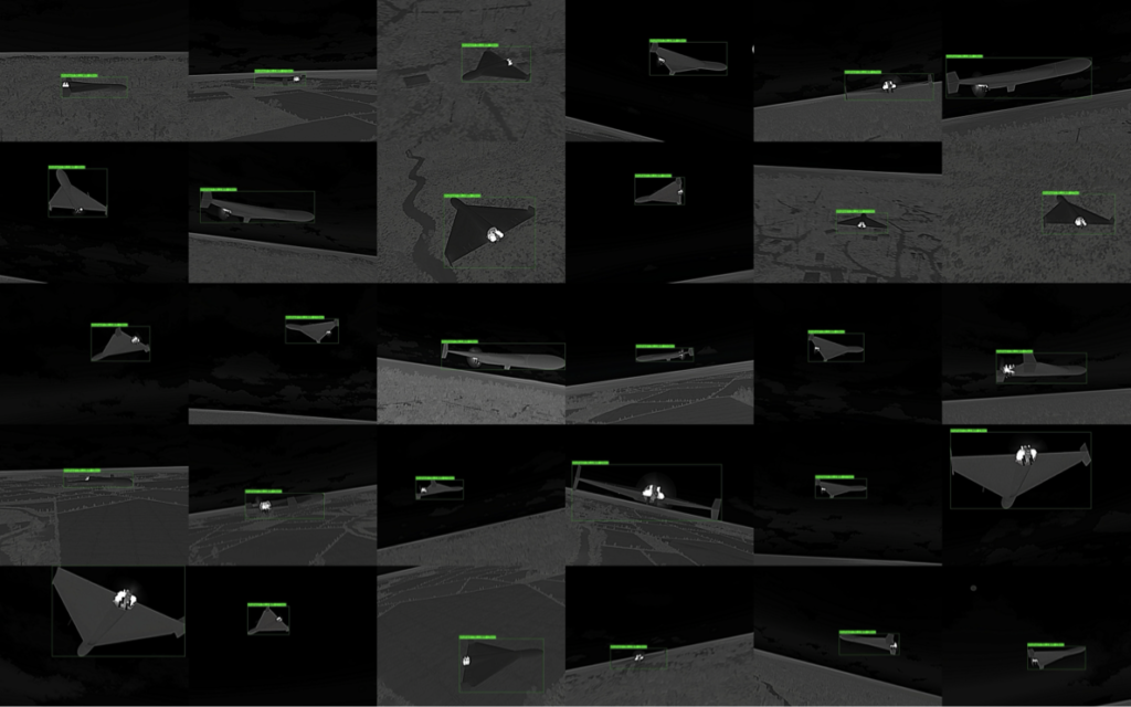
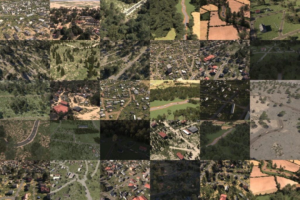
Procedural engines like those behind AI Verse’s Gaia and Helios parameterize scenes with physics-based rendering: vary object poses, textures, atmospheres via code, not diffusion models. This yields pixel-perfect labels (100% bounding boxes, segmentation masks) impossible manually, plus infinite diversity in occluded vehicles or drone swarms.
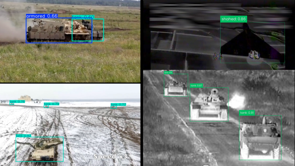
In tank detection tests, hybrid real-synthetic mixes boosted YOLOv8 mAP by 25% over real-only, converging 3x faster. Drone manufacturers use them for C-UAS: simulate rare low-light UAV intrusions, slashing false negatives by generating 1M frames overnight at a fraction of a price vs. $500k field equivalent.
Proven Use Cases in Defense CV
Synthetic images shine on object detection models: detecting partially foliage-hidden armor, detecting tanks from various angles, drone detection from thermal cameras are high altitude. Edge scenarios are easy to train for with accessible multispectral datasets with characteristics like dust, fog, lowlight, etc.
Aligning with 2026 Computer Vision Trends
In 2026, defense teams favor procedural synthetic data for its control and fit with new regulations like the EU AI Act, which favors synthetic datasets. Recent benchmarks confirm that synthetic imagery narrows the gap between simulated and real performance, a must-have for drone makers meeting tight C-UAS timelines.
Smart CV teams build feedback loops: train models, test on small real sets, then refine sim params for zero-shot generalization. Balancing classified real images with procedural synthetic ones results in deploying reliable models faster. This approach turns shortages into advantages for those ready to implement.

How to Convince Your Team to Invest in Synthetic Image Datasets
Transitioning from real-world data to synthetic datasets isn’t always easy, especially for teams that have relied on conventional methods for years. The most common objections include: The Case for Synthetic Data 1. Faster, Cost-Effective Data Generation Real-world data collection is slow and costly, often requiring extensive fieldwork and manual annotation. Synthetic datasets, on the other […]

Synthetic Data vs. Real-World Data: A Game Changer for AI Model Training
In the realm of AI and machine learning, the debate between synthetic datasets and real-world images is a pivotal one. Both have their merits, but when it comes to efficiency, flexibility, and performance, synthetic data is emerging as the clear frontrunner. Let’s explore why. Speed, Cost, and Flexibility: The Case for Synthetic Data Building a […]

Real-Life Data vs. Synthetic Data: How Computer Vision Engineers Allocate Their Time
Computer vision engineers are at the forefront of teaching machines to “see” and understand the world. Their daily practices, and ultimately the pace of AI innovation, are shaped by the kind of data they use—either real-life imagery painstakingly collected from the physical world, or synthetic data generated by advanced simulation engines. Let’s examine how these […]